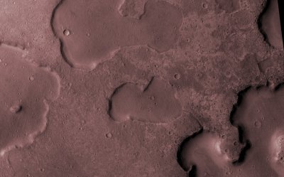
Three billion years ago, the red planet, Mars, was warm enough to sustain lakes of liquid water, according to satellite images just published in the journal Geology. Previously, astronomers had assumed that this period was simply too cold and arid for surface water.
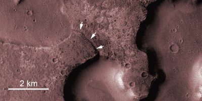
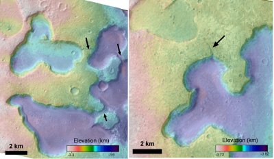
Researchers at Imperial College London and University College London now suggest that during the Hesperian Epoch, the Martian surface around the equator was spotted with lakes, each approximately 20 kilometres across, formed from melted ice. Earlier studies had hinted at the warm and wet early history of Mars during the period 4 billion to 3.8 billion years ago, well before the Hesperian Epoch. Detailed images from NASA’s Mars Reconnaissance Orbiter, which is currently circling the planet, suggest that there were later warm and wet periods; age is determined by meteorite crater count. The evidence lies in several flat-floored depressions located above Ares Vallis, a giant gorge that runs 2000 km across the equator of Mars.

According to Nicholas Warner, of IC’s Department of Earth Science and Engineering, “Most of the research on Mars has focused on its early history and the recent past. Scientists had largely overlooked the Hesperian Epoch as it was thought that Mars was then a frozen wasteland. Excitingly, our study now shows that this middle period in Mars’ history was much more dynamic than we previously thought.”
Warner and colleagues, Sanjeev Gupta, Jung-Rack Kim, Shih-Yuan Lin, and Jan-Peter Muller, claim that there may have been increased volcanic activity, meteorite impacts or shifts in Mars’ orbit during this period, which could have warmed its atmosphere enough to melt ice. This in turn would have bolstered the greenhouse effect temporarily, trapping more heat from the sun and making the planet warm enough for liquid water to exist on its surface.
Until now, the Ares Vallis depressions have remained a mystery to scientists, although they suspected that their formation was due to sublimation of ice directly to water vapour. The loss of ice would have created cavities between the soil particles, which would have caused the ground beneath to subside.

The researchers have now discovered small, sinuous channels that connect the depressions, which they say could only have been formed by running water, essentially making the sublimation theory redundant. The team also compared the Mars images with images of thermokarst landscapes on Earth in places such as Siberia and Alaska. Thermokarst landscapes are areas where permafrost is melting, creating lakes that are interconnected by the same type of channels the team says exist on Mars. The team says that the melting ice created lakes that may have burst their banks allowing water to carve pathways through the frozen ground from higher lakes into lower-lying lakes.
UCL’s Muller who works at the Mullard Space Science Laboratory who carried out the 3D mapping of the Martian surface, explains how modelling with sub-metre resolution allowed the team to test their hypotheses much more rigorously than ever before.

One thing that the scientists do not yet know is how long the warm and wet period lasted during the Hesperian epoch or how long the lakes remained liquid. Nevertheless, the study may have implications for so-called “astrobiologists” looking for evidence of life on Mars. The team say these lake beds indicate regions on the planet that may have once been suitable for some form of microbial Martian life. As such, they represent good targets for future robotic missions seeking out ancient life on Mars.
LINKS
Geology, 2010, 38, 71-74
http://dx.doi.org/10.1130/G30579.1
Video flypast