New insights into the differences between the subduction zones where the Earth’s tectonic plates slide across each other could aid earthquake prediction and allow seismologists to discover in advance whether an imminent earthquake will be weaker or as powerful as those that shook Indonesia in 2004, Alaska in 1964, Chile in 1960 and the Pacific Northwest United States in 1700.
Subduction zones lie at the sea floor just offshore and represent the region of overlap between two tectonic plates where one dives beneath the other. According to Christopher Fuller of the University of Washington not all subduction zones are created equal. He and his colleagues believe they have found the key to determining which subduction zones or specific areas within a subduction zone will push the needle farthest on the Richter scale.

(L-R) Fuller Brandon Willett
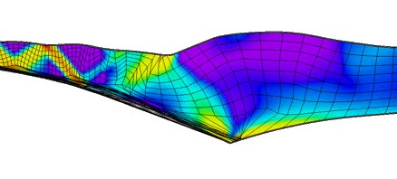
As one tectonic plate slides beneath another, enormous stresses build up where the two overlap. Sometimes this deforms the upper plate turning it into an enormous bowl-shaped depression that can fill with sediment from nearby rivers to a depth of around 3 km and sometimes more.
Fuller and his colleagues, Sean Willett also at Washington and Mark Brandon of Yale University, have found that the most severe subduction zone earthquakes occur where such sediment-filled basins have formed; why this should be so is unclear. The researchers simulated the forces involved during subduction and found that the weight of the sediment strengthens the edge of the plate directly above where the earthquakes happen. The stronger edge is deformed far less by subduction than nearby areas without such basins, Fuller explains. In many of them, the sediment will stop the deformation of the upper plate, he says, The simplest way to think of it is that the increased weight of the sediment stops the deformation from occurring. This increases the likelihood that large earthquakes will occur in regions with basins.

Subduction zone
The Cascadia subduction zone off the coasts of Washington, Oregon and northern California has forearc basins in several areas, Fuller adds. As it moves to the east at 5 centimetres a year, the Juan de Fuca tectonic plate slides beneath the North American plate that contains the landmass of the Pacific Northwest. The probability of large earthquakes is greatest in these areas. The modelling could have implications in figuring out where, within a subduction zone like Cascadia, such great earthquakes are most likely to occur.

Sean Willett
Fuller points out that forearc basins do not play the same role in the subduction zone off the Indonesian island of Sumatra, where the massive earthquake of 2004 triggered tsunamis that killed hundreds of thousands of people. You have to understand the nature of basins and how they work in each area before you can use them as an interpretive tool, he emphasises, You can’t just apply these correlations everywhere.
Further reading
Geology, 2006, 34, 64-67
http://dx.doi.org/10.1130/G21828.1
Geodynamics Research Group
http://www.ess.washington.edu/web/ess/research/structures/index.html
Mark T Brandon
http://earth.geology.yale.edu/~brandon/
Suggested searches
subduction zones
plate tectonics
earthquakes
Richter scale