Alaska’s North Slope is dotted with thousands of puzzling ovoid-shaped lakes that are among the fastest-growing lakes on the planet and have presented geological scientists with a conundrum for decades. New research now points the finger at seasonal warming of the permafrost for the lakes’ unusual characteristics.
Lakes come in all sizes and shapes, but they’re rarely oriented in the same direction, said Jon Pelletier of the University of Arizona in Tucson. The North Slope lakes, on the other hand, range in size from puddles to lakes more than 20 km long with their narrow ends all pointing northwest. Pelletier and his colleagues wanted to explain this environmental phenomenon and to understand why these oriented thaw lakes, which cover an area twice the size of the Scottish Highlands, have been expanding at rates of up to 5 metres each year for millennia.

Jon Pelletier
Geologists have puzzled over the evolution of this type of lake, which is found in the permafrost zone in Alaska, in northern Canada, and in northern Russia, for decades. They have posited explanations for the lakes’ shape and orientation based on wind-driven lake circulation and erosion by waves.
Now, Pelletier and colleagues have proposed a new explanation for the orientation, shape and speed of growth of oriented thaw lakes. The lakes’ unusual characteristics result from seasonal slumping of the banks when the permafrost thaws abruptly, they say. The lakes grow when rapid warming melts a lake’s frozen bank, and the soggy soil loses its grip and slides into the water. On Alaska’s North Slope, the prevailing winds blow perpendicularly to the long axes of the lakes. According to the traditional explanation, such winds set up currents within the lakes that erode the banks, particularly at the lakes’ ends. This was a textbook explanation that I didn’t find convincing, says Pelletier, so I decided to tinker around with alternative models.
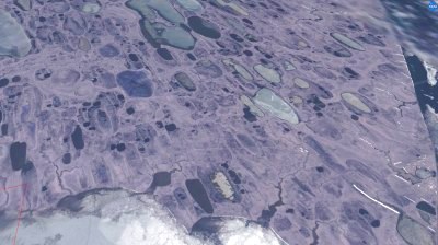
Colour version of an oblique-view LANDSAT image of the Alaskan lakes (Credit: NASA and American Geophysical Union)
We knew about the thaw slumping, but we didn’t know it had to do with the shape of the lakes, he adds. Pelletier developed a new mathematical model that predicts the observed pattern of lake growth and orientation very precisely. The computer allows you to put the processes into the model and ask, ‘If the winds blow this way, what kind of a lake would you expect to see?’ or ‘If it’s from thaw, what would we expect to see?’ You do still need to go and see, do the winds blow this way or does the thaw happen that way?
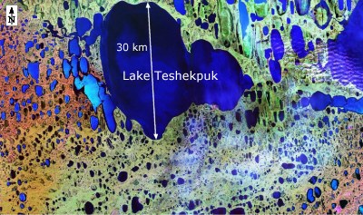
False-colour birds-eve view of the LANDSAT image of the largest oriented lake in northern Alaska (in fact, several merged lakes) (Credit: NASA)
When the lakes experiences thaw slumping, Pelletier’s model predicts that they will grow more in the downhill direction than uphill, generating the lakes’ characteristic elongated-egg shape. Pelletier tested his thaw-slumping model against the wind-erosion model using satellite images to create a database that describes 1,400 of northern Alaska’s oriented lakes. When he compared them by size and soil type, he found that more big lakes occurred on fine-grained soil, providing support for the idea that thaw slumping, not wind, formed the lakes.
Pelletier’s next step will be to see whether the lakes have indeed grown more in the downhill direction, as his model predicts. It’s so simple and low tech, he said. It can be done by comparing aerial photos over time but no one’s done it. There are a lot of photos from past decades.
Further reading
J Geophys Res, 2005, 110, F02018
http://dx.doi.org/10.1029/2004JF000158
Jon Pelletier’s Research Page
http://geomorphology.geo.arizona.edu/