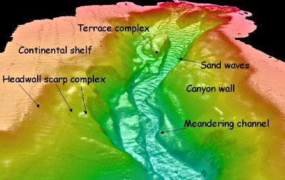
Monterey Canyon extends from shore to about 100 kilometres off the central California coast. It is one of the world’s largest submarine canyons and harbours some of the deepest, darkest secrets on the planet.
Now, Douglas Smith of the Division of Science and Environmental Policy, at California State University Monterey Bay, in Seaside, California, and colleagues Genoveva Ruiz, Rikk Kvitek, and Pat Iampietro have made new advances in submarine imaging technology that have enabled them to view the canyon as if all the water was removed. Their technique of 3 m resolution 244 kHz multibeam seafloor bathymetry has a 0.5 m depth precision and so can reveal geomorphology with detail enough to allow researchers to interpret small-scale features and short-term processes in the upper 4 km of the canyon.

Eastward view toward Monterey Canyon head from a position 2 km down canyon from the shore derived from a digital elevation model
We have processed a variety of very high resolution images of the shallow portion of the canyon between the depths of 10 and 275 m, explains Smith. These new detailed views have lead to a clearer understanding of how this submarine canyon has evolved. The researchers re-imaged the canyon over both a 24 hour period and a six month period and so could see how quickly the canyon is changing shape through erosion and deposition of sediment. Our results show that the canyon is far more active than previously believed, adds Smith.
The team has discovered new large sand dunes on the floor of the canyon that migrated and completely changed their shapes over the course of six months. Our work suggests that the near-shore part of the canyon is in a long-term phase of enlargement, says Smith. This is counter to previous studies in the region. The researchers add that there was no measurable sediment loss or gain over the 24 hour period.
Several research groups are focusing on Monterey Canyon for a variety of reasons beyond the esoteric drive to understand natural submarine canyon phenomena, Smith told Spotlight. Some practical applications of the collective work includes managing canyon ecosystems, understanding coastal erosion and tsunami hazards, and assessing potential effects of harbour dredge material disposal, he says. The canyon is the heart of the Monterey Bay National Marine Sanctuary; its currents, nutrients, and shape help define the broader ecosystem and regional climate along coastal central California.
Further reading
GSA Bulletin, 2005, 117, 1123-1133
http://www.gsajournals.org/perlserv/?request=get-abstract&doi=10%2E1130%2FB25510%2E1
CSUMB Watershed Institute
http://watershed.csumb.edu/wi/
Seafloor Mapping Lab
http://seafloor.csumb.edu/
Suggested searches
bathymetry
submarine canyons